
Land North And East Of Manor Farm Bainton Road Bucknell
Summary
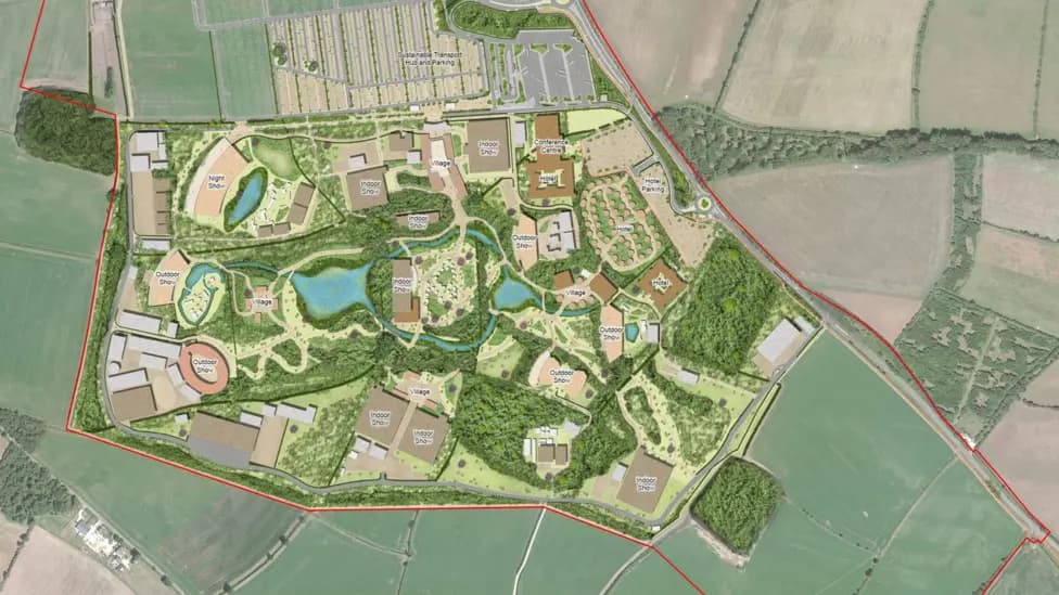
Outline application with all matters reserved for tourism development Including outdoor and indoor theatres, restaurants, hotels, conference facilities, offices, warehousing and storage, security control centre, medical centre, animal facilities (including stables, aviary, animal sheds), laundry facility and workshops, and supporting infrastructure including waste management centre, wastewater treatment facility, energy centre and sub-stations, photovoltaic (pv) solar panels, water storage tanks and pumps, lakes and water management systems, structural landscaping, internal footpaths, internal vehicular routes, active travel routes, parking and access (outline masterplan).
Our Response
1. INTRODUCTION
Bicester Bike Users' Group ('BBUG') objects to the current plans because, while engagement has been good, and there is much to commend about the proposals, there are still issues that need to be addressed and resolved from a cycling perspective.
BBUG notes that in the submission the version of the Local Cycling and Walking Infrastructure Plan ('LCWIP') maps for Bicester relied on are the early 2020 drafts which are out of date and do not match the 2023 update.
2. JUNCTIONS
In general, it would be preferable for the active travel path approaches to the large junctions to run parallel and set back from the carriageway to be crossed, and then require users to turn 90º to make the crossing to discourage cyclists from heading directly across, risking a collision with inattentive drivers. An example is provided by the Dutch CROW V32 design below.
2.1 Main Visitor Entrance (North)
The three active travel crossings are significantly offset from one another, unnecessarily increasing the distance to be traversed by cyclists (and pedestrians) thereby discouraging walking and cycling. It would be much more convenient if these were aligned with sufficiently wide refuges between the carriageway (marked in green) as per the V32 arrangement.
2.2 Secondary Visitor Entrance (Centre)
The angles of approach of the cycle lanes are too oblique and may encourage cyclists to proceed directly across the parallel crossing without slowing down, stopping, or looking, posing something of a collision risk with inattentive drivers. It would be preferable to adopt the Dutch CROW V32 design and have the approaches closer to parallel to, and setback from, the carriageway with a 90º turn prior to making the crossing. This would be more similar to the arrangement of the main visitor entrance (marked in green). For user legibility, the approach angles, setback etc, of each of the crossings should be consistent.
The slip lane for cyclists to join the carriageway is not compliant with standards as there needs to be a longer transition plus a reasonable length of marked cycle lane on the carriageway (point circled in red). There also needs to be a corresponding slip lane on the exit on the opposite side to allow cyclists to exit the carriageway and join the cycle facilities. To accommodate this, it be necessary to have a corresponding shared pedestrian/cycle area on the north side of the crossing.
2.3 Watergate Lodge Crossing
Rather than a mini-zebra (marked in red) which will be poorly observed by cyclists due to the energy lost by stopping (equivalent to cycling a distance of 100m), better to provide a wider area of shared path to enable cyclists and pedestrians to navigate past each other without stopping and to enable both users to reach the shared area for the uncontrolled crossing without conflict.
3. PUBLIC RIGHTS OF WAY
The effect of constructing a large facility that attracts a considerable volume of motor vehicle traffic is that it will render the carriageways unattractive for active travel access due to the real and perceived risks. The direct active travel paths to Bicester mitigate this well, but the villages surrounding the site risk being cut off to some extent by the development traffic. The bridleway network provides a good alternative network for access between the villages, but because the surface quality of the bridleways is poor (almost wholly dirt), this can only be used by cyclists in dry weather.
Upgrading of the immediate bridleway network with proper all season surfacing suitable for all users would significantly mitigate this adverse impact on the surrounding villages. In particular, the following bridleway surfaces should be upgraded: from site to Ardley & Fewcott (367/1/10-20); Bucknell (148/1/20); Bainton (367/9/10); and Stoke Lyne (367/5/20).
BBUG agrees that a crossing point for all users over B4100 to access the bridleways to Bainton and Stoke Lyne is essential.
4. INFRASTRUCTURE WITHIN BICESTER
4.1 Braeburn Avenue
We would prefer a parallel crossing closer to the main carriageway, with a 5m setback to provide a waiting area for cars. Research shows that this is the safest setback distance for crossing. The current crossing is far too set back, meaning it will be generally ignored, with users crossing at the desire line instead (marked in green).
The short section of shared path on the southern side of the B4100 should continue to the proposed shared path and parallel crossing to St Laurence's Church (marked in turquoise) and then on the opposite side to Aunt Em's Lane, which would provide a connection between Elmsbrook, the development site, and Caversfield / north Bicester.
4.2 Charlotte Avenue
We have concerns whether it will continue to be safe to cycle on the carriageway through Elmsbrook given committed and pending developments given the predicted future increase in vehicle numbers. Charlotte Avenue is particularly constrained. It may be preferable to continue the cycle paths along the B4100 rather than assuming that it will be suitable to cycle on the carriageway through Elmsbrook.
4.3 Bure Farm / Lucerne Avenue
It is good to see attention being paid to the Lucerne Avenue diversion and we welcome the proposals to upgrade the link and crossing over this road. We would note that the LCWIP specifies a minimum shared width of 3.5m for shared paths, and it would be preferable to also have a vegetated buffer from the carriageway. A parallel crossing, set back 5m from the circulatory carriageway, would be essential.